DESOLATION CANYON and LOWER STIKINE
In the Summer of 2006, I participated in two multi-day river trips.
The first, from July 19 to 24, was through Desolation and Gray Canyons
of the Green River in Utah. These are wilderness canyons ending just
north of the town of Green River. The second trip was down the Lower
Stikine River in northern British Columbia. We launched from
Telegraph Creek on August 4 and arrived in Wrangell, Alaska on August
12. On August 14, we returned to our cars at Telegraph Creek by jet
boat.
The trips presented a strong contrast. The Green River flows
through desert redrock country with low vegetation, very silty water,
and a dry, hot climate. The temperatures were near 100 F during our
trip, which was made bearable by the option of swimming at nearly any
time. The river was running 1800 to 2400 cfs and has rapids of of
about class 3 at that level. The Stikine is a huge river running
through a wilderness of rainforest, mountains, and glaciers as it
penetrates the BC/Alaska coast range, a part of the world from which
the ice age has not fully retreated. It has little in the way of
rapids, but with a current that runs at 6+ mph for almost the whole
distance and a flow of 80,000 to 100,000 cfs near the mouth when we
were there, it is a big, pushy river whose whirlpools and
crosscurrents require serious attention. Capsizes by canoes do
happen, especially in the higher water such as existed the week or two
before our trip when the flow was almost 200,000 cfs - as big as the
Columbia at the time. The weather varied from near room temperature
and partially clear to cool and rainy with the latter prevalent near
the coast. The usual bane of northern trips, bugs, were mostly
absent. In fact, there were nearly as many on the Green.
The participants in the Desolation Canyon trip were Kerry Luttrell,
Ron Thomas, Janet Brook, Pete, Jen, and Phil Whiteis, and myself
(Craig Walker). All are from Socorro, NM, except Kerry who is from
Nanaimo, BC. For the Stikine, we had Kerry, his wife Sharon, and Ron
Bollans from Nanaimo plus myself. Ron Thomas was supposed to go, but
was unable to because of a flooding situation at his house near
Socorro. The rains had come with a vengence after nearly no
precipitation since October. On the Green river, we used rafts - one
self-bailer and two catarafts. On the Stikine, Ron and I used the
larger cataraft while the Luttrells used a canoe. For some of us,
these trips were the first experience rowing a raft, although we all
had experience with canoes and kayaks in whitewater and with long
wilderness trips.
These trips involved considerable time on associated logistics.
There were 2 days of driving before launching on the Green (plus Kerry
flying from Canada). Then my car got left in Salt Lake City for a few
days while I returned to work. After flying back to Salt Lake, it was
a 2 day drive to my sister's place near Calgary and most of 3 days to
get from there to Telegraph Creek, including meeting the others and
shopping for the trip in Prince George. Afterwards, I took 10 days to
get home, including a day layover at the Luttrell's cabin at Deka Lake
and an overnight canoe at Waterton Lakes with my sister. There are a
minimum of about 5 days of driving to get between Socorro and
Telegraph Creek, which is close to the Yukon.
Below is a selection of photos covering both trips.
All were taken with my Panasonic FZ20.
DESOLATION and GRAY CANYONS
RETURN TO PREVIOUS INDEX
Click on the image for a screen size version.
The "full size" version is larger (not available in web versions).
| Ron and Janet in Ron's Infinicat on the river not far from the
launch area at Sand Wash.
|
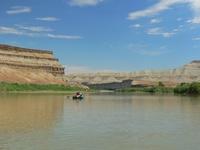
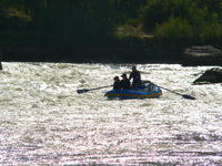
| On the river in Desolation Canyon.
|
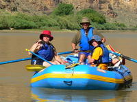
| The Whiteis family on the river.
|
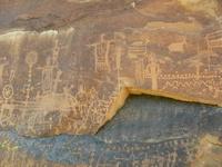
| Petroglyphs near Flat Canyon.
|
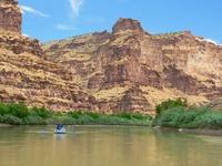
| Ron and Janet running Steer Ridge Rapid (I think).
|
| Kerry preparing to run Wire Fence Rapid with the Jaguarundi. I
would normally have been riding the raft when he was rowing, but for
this rapid I was on shore trying for some photos.
|
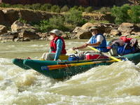
| The Whiteis's in Three Fords Rapid.
|
| Surviving the heat. On this occasion, the swimmers, with occasional
intervention from the rowers, were playing catch with a ball someone
found.
|
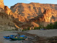
| Camp at the base of Rattlesnake Rapid.
|
LOWER STIKINE RIVER
RETURN TO PREVIOUS INDEX
Click on the image for a screen size version.
The "full size" version is larger (not available in web versions).
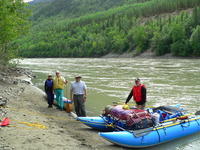
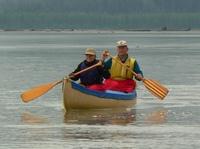
| Ready to depart from Telegraph Creek, below the Stikine Riversong.
Left to right are Sharon and Kerry Luttrell, myself and Ron Bollans.
The raft was not needed for whitewater on this trip, but it is a
comfortable and safe way to do this river. There is no worry about
a capsize or swamping. In fact, we generally went straight for the
biggest waves we could find. With the strong current, the extra speed of
the canoe doesn't really shorten the trip much.
Stikine Riversong provided a campsite,
restaurant meals, parking for our vehicles, and the jet boat haulback
from Wrangell. They have rooms on site, but were full.
|
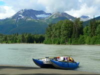
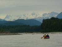
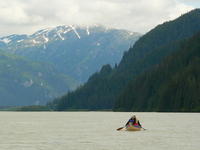
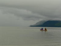
| A typical scene along the river - water, forest, mountains, and
glaciers (a small one in this case).
|
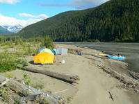
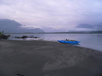
| Our camp a couple of km below Skud Portage.
|
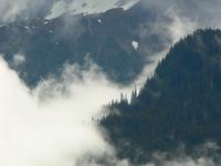
| Mountains and glaciers reaching into the clouds above the Stikine.
|
|
|
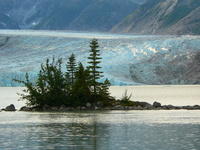
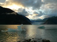
| The Great Glacier and Outflow Lake. We spent a layover day at the camp
near the Great Glacier and walked to the lake twice. We were at a
forestry campground complete with picnic tables and fire rings.
|
| The skyline near the Great Glacier late in the day.
|
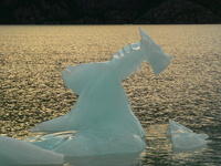
| A small iceberg in the Outflow Lake at the Great Glacier.
|
| The Great Glacier and Outflow Lake late in the day.
|
|
|
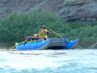
| The cataraft at our last camp on the river.
|
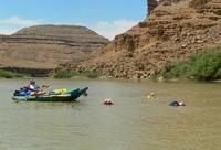
| Kerry and Sharon working through the mud flats of the delta.
|
| Crossing the delta and some ocean to Wrangell
in calm, but cloudy conditions. The first portion of the crossing
mainly involved trying to find deep enough water through the mud
flats. Several times, we had to push the raft. Remarkably, it did not
rain much on us despite what was going on not far away. For the
final part of the crossing, the tidal currents dominated and we,
knowingly because of the usable weather, were crossing on the
wrong, incoming, tide. With an outgoing tide, we probably would
have had good current all the way to the harbor. As it was, we
had to wait for a while for the currents to slow to get around
the top of Wrangell Island. |
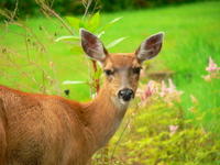
| A deer at the Grand View B&B, where we stayed about 2 miles
south of Wrangell. We can certainly
recommend that facility for lodging.
|
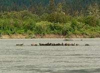
| A group of seals sunning themselves on a sand bar along the river
|
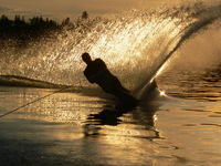
| On the way home, we stopped at the Luttrell's place at Deka
lake. This photo is of Kerry's son-in-law, Ryan, water skiing. I
include it here because I like the photo.
|