Navigation: Index page
Checking the feasibility of a Fr 39 to Tr 8 connector trail.
On August 29, 2023, I hiked from Water Canyon campground to North
Baldy. On the way up, I attempted to follow old trails and game paths
from the last stream crossing on Forest Road 39, two switchbacks above
the cabin, to the North Baldy to South Baldy ridge where Trail 8 is
located. I had done this before, at least going down, so I knew it
should work, but that it would be hard to navigate.
The path starts as a good trail and looks like it had been
maintained at some past time. It was not even very overgrown
suggesting it was getting some use. This was true while it was
following the stream. Once it shifted onto the hillside, above a
stream fork, it got harder to follow. Several times, I basically
could not figure out which option to take and probably did not make
the correct choice which led to some bushwhacking. After a while, I
would pick up what seemed to be trail again, although overgrown.
Eventually I came to an old mine site. This may be the reason there
seems to be a built trail here.
I think that a usable trail could be provided here mainly by
clearing brush and marking the path. The hardest part will be to
figure out where the old trail went and to distinguish it from game
trails. It may take some systematic searching of the hillside in
several places. That search would be easier if one could clear brush
along suspected paths, but that wouldn't be good if you turned out to
be in the wrong place. In any case, this might be an opportunity to
open a new trail without actually doing any tread work, which might be
useful since tread work requires a significant approval process to be
sure no archaeological sites are disturbed.
A note for anyone else trying this - wear sturdy clothes with long
legs and sleeves. Much of the brush has thorns. I had pretty bloody
arms by the time I got to the top, even with poles to help push things
aside. That was part of the reason I did not go back down that way as
originally planned. Instead, I followed Tr8 to the summit cone and,
since I was so close, went to the top - something I had not planned
on doing that day.
A GPX track of this hike with waypoints and photo points can be
downloaded from
Water_Canyon_to_North_Baldy_via_cutoff_to_Tr8.gpx
An image from the gaiagps mapping app showing the areas of interest
here is available at Gaia_track.jpg. A
zoomed in version is at Gaia_track_zoom_in.jpg. In these
images, my track is in orange. Unfortunately the uncertainty in the
GPS positions is rather clear from the scatter when I was moving
slowly or stopped. The tracks were made on an iPhone. The red track
was made before the hike using Google Earth by looking for features
that might be trail.
An image from Google Earth showing the tracks in the area of the
cutoff is in
Fr39-to-Tr8-Google-Earth.jpg. This time the actual track is in
blue and the hypothetical one based on looking at Google Earth is
in white. It is clear I did not follow the hypothetical one in
many places. Perhaps it would have been better if I had.
Click on the image for a screen size version.
The "2000" and "full size" versions are larger (not available in web versions).

No photo waypoint. Taken just above the "Bottom
of Cutoff" waypoint. The trail almost looks maintained.
|

Gaia waypoint "My Photo - 8/29,23, 9:52:50AM. All along the
gully, the trail was good.
|

Gaia waypoint "My Photo - 8/29,23, 9:57:20AM. A stream crossing
that looks built.
|

Gaia waypoint "My Photo - 8/29,23, 10:06:06AM. The tread is
still good but more overgrown. I think I lost it soon after.
|

No photo waypoint. From about position of
last photo (11 seconds later)
|

Gaia waypoint "My Photo - 8/29,23, 10:35:02AM. If you peer hard,
you can see the trail.
|

Gaia waypoint "My Photo - 8/29,23, 10:36:51AM. The
trail here really looked built. But I had problems finding it to
this point.
|

Gaia waypoint "My Photo - 8/29,23, 10:40:59AM. I found some more
open trail here.
|

No gaia waypoint. About 27 seconds after previous so from
same spot. The pole marks where I came out into the more open
trail from where it was reasonable tread, but badly overgrown.
|

Gaia waypoint "My Photo - 8/29,23, 10:56:44AM. It looked
like tread, but is hard to see, especially in photos,
thanks to the overgrowth.
|

Gaia waypoint "My Photo - 8/29,23, 10:59:23AM. The old
mine that might account for the presence of an old trail.
|

Gaia waypoint "My Photo - 8/29,23, 11:06:34AM. Looking
down. The mine is behind the rocks on the left.
|

Gaia waypoint "My Photo - 8/29,23, 11:23:37AM. The slopes
below the saddle. The paths in this area are a bit more
like game trails.
|

Gaia waypoint "My Photo - 8/29,23, 11:27:14AM. Approaching
the saddle shortly before the trail turns northwest to
attain the saddle. This route ends on one of the trails
heading southeast from the saddle, not the one running along
the base of the rocks to the northeast.
|

Gaia waypoint "My Photo - 8/29,23, 12:12;13PM. Looking back
toward the saddle from the ridge below North Baldy.
|

looking back along the ridge trail, which goes up over the rocks. The
move over the rocks is not hard, but is a bit trickier and more
exposed than you would normally find on a trail.
|

Gaia waypoint "My Photo - 8/29,23, 12:15:57PM. Looking back
toward the saddle from just before Tr 8 meets the road from
Kelly.
|

Gaia waypoint "My Photo - 8/29,23, 12:33:53PM. From the top
of North Baldy looking south.
|

No Gaia waypoint. The two survay markers and the
memorial to the B17 crash on the summit. The memorial
plaque is new since my last visit. There was an article
in the Defensor Chieftain recently about it.
|
I don't seem to have a photo corresponding to the waypoint
My Photo - 8/29/23, 1:03:56. Some bookkeeping error
occurred and the photo got lost. There is no gap in the iPhone
sequence numbers.
|
Gaia waypoint "My Photo - 8/29,23, 1:11:28PM. Looking over
the trail area from Fr39.
|

Gaia waypoint "My Photo - 8/29,23, 1:16:16PM. The
location of the slide that Rob found was impassible not long ago.
It has been seriously worked on.
|

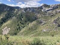
Gaia waypoint "My Photo - 8/29,23, 1:45:28PM. Looking
toward the cutoff area from a bit above its start. The cutoff
starts below the talus patch in the lower left, goes up to
the right of that in the sparse trees, then cuts back to the
left to reach the lowest point on the ridge.
|

Gaia waypoint "My Photo - 8/29,23, 1:47:28PM. The start
of the cutoff as it leaves Fr 39. This doesn't show it
well - it's a big wide path probably in active use by cows.
|

for the arch reported by Peter Napier. I thought it might be on this
rock formation, but later saw a better candidate.
|

No Gaia waypoint. Another shot of the formation in the last
photo.
|

Gaia waypoint "My Photo - 8/29,23, 2:38:52PM. Time
difference between photo EXIF and waypoint is 12 seconds
which seems large. Anyway, I think the arch is in the
right formation here. I was standing in a small clearing
to the northeast of the trail. I showed Peter this photo and
he thought it is right, but seemed a bit uncertain, probably
because of a different viewing angle from what he had seen.
|

No Gaia waypoint, but same position and target as as the
previous photo.
|
Navigation: Index page