Navigation: Index page
This is arguably my most significant trip. It was done with M.I.T. Outing Club people in 1975, nearly 50 years ago as I edit this web page. We made the first ascent of the Northeast Ridge of Mt. Vancouver in the St. Elias range, Yukon Territory, Canada. Mt. Vancouver reaches 15,825 feet, the 15th highest mountain in North America. The relief is huge. The summit is only about 23 miles from the ocean in Disenchantment Bay and the surrounding glaciers are at roughly 5000 ft elevation. The expedition spent 26 days in some of the most isolated and rugged country in North America. The only other people we saw during the whole time were a ranger and helicopter pilot who visited very early in the trip during a mission to set a fuel cache in the central part of the range and the helicopter pilot who flew two of our group and our climbing supplies out of the range before the rest walked out. That walk took 7 days, 6 on snow and ice, to reach the nearest civilization at Kluane Lake on the Alaska Highway.
The following is the article written by Barton DeWolf and published in the 1976 issue of the American Alpine Journal. It describes our climb.
"
Barton DeWolf"
While we were getting ready for our flight, we met a Japanese party that had just climbed Mt. Vancouver from the north, using what we had considered as a backup route.
Mt. Vancouver has three summits of nearly equal height. The south summit is one of the defining markers of the U.S. - Canada border. We climbed the north summit which is thought to be the highest of the three by a small margin. A proper analysis of the photo taken toward the South Summit from the North Summit might be able to help confirm which is highest, but a casual analysis is hampered by a hazy horizon over the ocean.
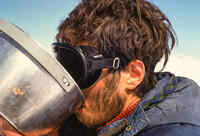
Note that I was known as Bob Walker in the Outing Club. My full name is Robert Craig Walker and I normally go by my middle name. My attempts to switch to Bob in college failed, other than in the Outing Club, because too many people knew my family and knew me as Craig.
As noted, the trip was over 50 years ago. Since then, three members have passed away (Ledoux, Dangle, and Milne (on Everest)) and the other five are still around and in touch. In fact, this upgrade of my web page was triggered by a discussion among our group. In October of 2025, we all had a reunion in New Hampshire. Photos from that event are in a separate show reachable from the web site index page. Also reachable is a show with some (eventually all) of the photos that did not make it into the edited show here.
Photographic details:
The photos were taken on Kodachrome 25 or 64 (I forget which) which were new at the time and had a color balance issue. The camera was a Konica Autoreflex T3. Shortly after the trip, I made a slide show of 122 images. Most, but not all, were mine. Some were duplicates. Unfortunately the slide duplication technology (slide to slide) was not too good, so the quality of those duplicates was not so great.
I had a dozen slides digitized to PhotoCD in 1996 as part of a come-on offer when I bought a printer. Later I acquired a Minolta Dimage Scan Elite film scanner which I used in 2006 to scan the first 56 images. But that is fairly tedious, and I got very busy so I did not finish the project. The scanner was always fairly slow, and then, when I got my Mac Pro in 2009, basically became obsolete because of its SCSI interface. The project languished until I retired at the end of 2014. I then set up my DSLR, a Pentax K5 with a 100mm macro lens, on a kludged mount using the slide holding end of an old slide duplicator (originally for the Konica) and proceeded to copy the rest of the slides by photographing them. The raw (DNG) images were processed in Lightroom. I also went back to the tif files from the scanning and redid most them in Lightroom for consistency. In the end, I think the best copies, and certainly the highest resolution (although the resolution is film limited) were from the camera so that worked well. One side effect is that the EXIF data associated with the photos are for the duplication process, not the original film photograph.
The duplicates are labeled in the captions as such. Those photos were taken by other members of the party. Several appeared in a recent slide show by Bart DeWolf, so were taken by him. It is possible that they are all from Bart. I needed other's photos because it was too dark on my helicopter flght in, and my photos of the key ridge climb were underexposed.
I have begun a project to digitize the slides that did not make it through the original selection, which was done in 1975. Many are very good, but I needed to fit in one carousel which meant only about a third could be in the show. Since this was ultimately my most significant trip, I plan to digitize all. The extras will be in a separate show, reachable from the web site master index.
These photos were scanned recently from nearly 50 year old slides. The slides are still in near perfect condition. Kodachrome is very good film.
Now the photos. Click on the small photo or the caption to see a
larger version, suitable for screen viewing. Full size versions are
available on request.
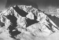
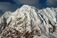
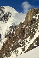
A photo by Brad Washburn of the east side of Mt Vancouver. Bart was in consultation with Brad Washburn on possible routes and Brad requested this photo and some others from the National Geographic Society once we were reasonably sure of which routes interested us. |
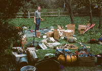
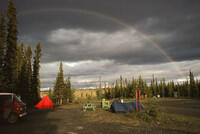
Inspecting and sorting gear at Pine Creek Campground near Haines Junction. My logs say Pine Creek Campground, but modern maps show a Pine Lake Campground in about the right place. |
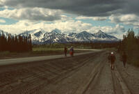
Along the Alaska Highway. Some of the crew flew to Whitehorse. Others drove a van up the highway. |
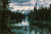
Somewhere along the Alaska Highway. |
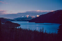
A lake along the Alaska Highway. I don't recall which. |
Yet another scene along the Alaska Highway. |
This is probably our staging area at Pine Creek Campground. |
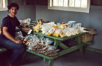
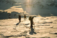
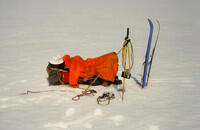
Packing the food. We packed the food in bags, each meant for one full day for 4 people. A single such bag fed all 8 of us at the start of the trip. Two bags were about right for the climb. On the hike out, when we had 6 people, we had 6 man day packs which left us hungry. We were burning a lot of energy. |
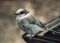
A camp robber. |
Walking along the Alaska Highway. The airport was pretty close to camp, so we may have been going there. |
The first of the three helicopter flights to our Base Bamp left at 8 pm on June 16, 1975. It was basically dark for the third flight, which I was on. |
Duplicate. Part of the St. Elias range from the flight in. It was too dark during my flight to take photos, so these are from someone, probably Bart, on the first flight. |
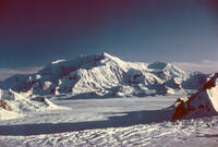
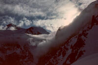
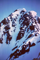
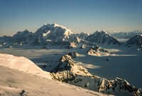
Duplicate. A view of our target, Mt Vancouver, from the flight in. The upper part of the northeast ridge is roughly centered in the photo. The lower part of the ridge curves around to the left. |
Duplicate. Another view of Mt Vancouver with the Northeast Ridge centered. This looks darker and from a higher flying helicopter so it might be from the second flight, in which case it was taken by Rob Milne. |
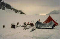
The helicopter at Base Camp. We're back to my photos. It never really got completely dark. In fact, we did most of our climbing at night for firmer snow and fewer avalanches. |
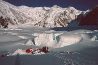
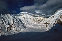
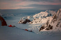
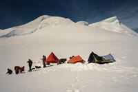
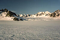
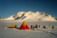
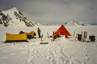
Our Base Camp on the Hubbard Glacier below the Northeast Ridge of Mt. Vancouver. We explored several options for how to start the climb and didn't really like any of them because of possible avalanche issues. |
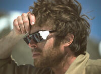
Bart DeWolf. |
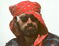
Paul Ledoux |
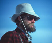
Hal Murray |
John Yates |
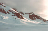
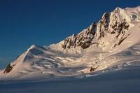
Looking northwest along the side of Mt Vancouver. |
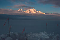
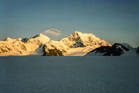
Mounts Hubbard and Alverstone, both US/Canada border peaks, from our camp. |
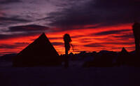
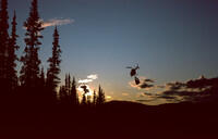
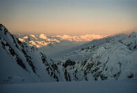
A sunset picture from Base Camp. |
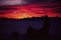
Another sunset picture from Base Camp. |
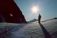
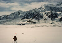
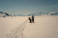
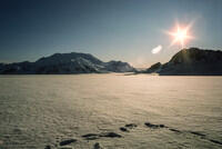
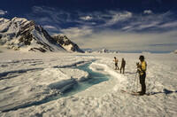
We skied along the glacier to examine various possible starts. |
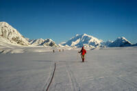
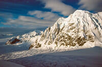
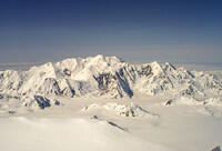
Another scene from our ski along the Hubbard Glacier. The big mountain in the background is Mt. Logan, the highest in Canada, second highest in North America, and one of the bulkiest mountains in the world. It's seen end on here. |
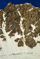
The lower part of the East Ridge of Mt. Vancouver. |
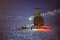
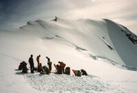
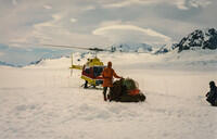
On June 18, at Base Camp, we watched a helicopter place a cache of fuel on the ridge above our camp - the wide, smooth snow structure in the center of this picture. They then dropped by for tea and a chat. We had been sleeping because of our night schedule. |
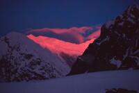
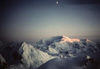
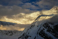
Sunset alpenglow looking up Mt. Vancouver. |
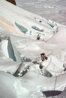
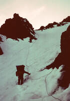
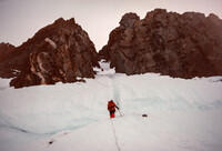
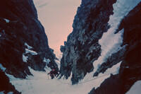
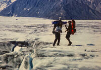
We opted to take a route up the icefall south of the toe of the Northeast Ridge. Being among the seracs was a bit freaky, but did not seem as dangerous as being below obvious avalanche chutes on other alternative routes. |
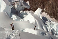
More seracs in the icefall. We made multiple trips through this to move all our gear. On the way down nearly 2 weeks later, we found some of our tracks on the sides of seracs. Clearly there had been motions. |
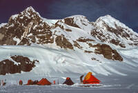
We camped first above the icefall at about 6400 ft, then made an Advance Base Camp (Camp 2) on a large shoulder at around 7700 ft. Basecamp on the Hubbard Glacier was at around 4500 ft. |
This is the first camp just above the icefall with the summmit of Mt. Vancouver in the background. |
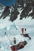
With our night climbing schedule, sleep time wasn't very cold despite all the ice. We joked about emergency bivouac gear being a tube of sun screen and a turban. |
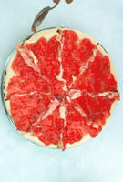
Dessert from one of our meals. |
Duplicate. Climbing from the first camp above the icefall to the shoulder where we put the Advance Base Camp. We placed some fixed rope in here because of the multiple trips and very heavy packs. |
Duplicate. Higher in the gully leading to the shoulder. |
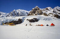
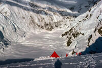
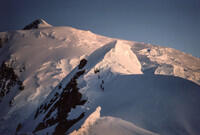
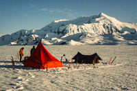
The Advance Base Camp on the shoulder. We placed the camp slightly down the side of the shoulder for some extra shelter from the wind. Our route from here went straight up the right of the two main gullies on the face above camp. That gully tops out where the two sides of the face converge. |
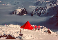
Duplicate. One of the tents at Advance Base Camp. The black plastic sheet in the foreground was an attempt, somewhat successful, to melt snow without using fuel. |
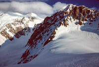
Looking from Advance Base Camp on the Northeast Ridge of Mt Vancouver toward the East Ridge of Mt Vancouver and Mt. Foresta in the distance. |
The cornices along the East Ridge of Mt. Vancouver. There were frequent avalanches on this face. |
Looking up the valley between the East and Northeast Ridges of Mt Vancouver. A later party, I believe, used that valley to get to a more direct approach to the peak. Given the avalanches we saw, that seems very dangerous. |
A wider angle shot of the same valley as the last picture. |
Bart with Mounts Hubbard and Alverstone in the background. |
From Advance Base Camp |
Advance Base Camp looking over Mt. Foresta and the Hubbard Glacier |
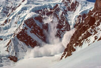
An avalanche across from Advance Base Camp. |
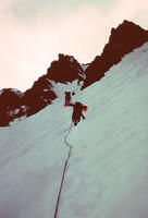
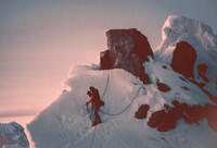
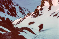
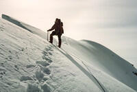
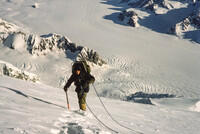
Climbing the gully above Advance Base Camp. We fixed ropes in the gully. After moving to the high camp, and climbing the summit, on descent we found some of those ropes broken from snow/ice/rock fall. |
Duplicate. In the gully. My photos of this section and the ridge are underexposed so these are duplicates of slides from others, probably Bart. |
Duplicate, probably from Bart. Along the ridge above the gully. Some of these cornices had fallen by the time of our descent. |
Duplicate. Photo by Bart DeWolf. Another shot of climbing along the ridge. I believe the climber is Hal Murray. |
Duplicate. Photo by Bart DeWolf. A rock step along the ridge. The climber is me (based on clothes and gear). |
Duplicate. Photo by Bart DeWolf. After a stretch of roughly horizontal ridge, we had another gully to traverse to and climb. This one was wider and easier than the first. At least two climbers are visible in this photo. There should be 4 on the rope but they are hard to distinguish from the rocks. On the way down, Paul's sleeping bag detached from his pack in this area. Days later it was recovered from the glacier far below. |
Duplicate, Probably from Bart. Climbing the upper gully. |
Back to my photos. Looking down the Northeast Ridge of Mt. Vancouver from the top of the upper gully. The route traversed the sharp ridge to where it splits, which was at the top of the lower gully. Part of Advance Base Camp can just be seen on the wide shoulder below to the right of the right branch of the ridge. The climber might be Bart. |
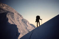
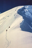
Following the ridge above the upper gully, trying to stay well back from the edge. |
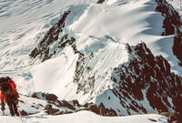
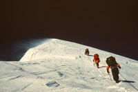
Continuing above the gullies. A 4 man team is visible in the distance. |
Rob Milne and our tracks along the back side of the cornices. |
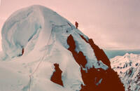
Placing our high camp at about 10,500 ft above the technical sections. |
Looking ahead from the high camp (Camp 3). There were some short, low-angle, ice slopes above here, but it was mainly a snow slog to the summit. |
The view from the high camp. |
There was still some relatively easy ridge above the high camp. We originally intended to place another camp, but, with good weather in hand, decided to make a one day push to the summit during the night of June 28-29 and well into the following day. |
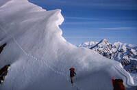
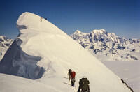
More of the final ridges and cornices. Note the 4 man team above the cornice at the bottom of the photo. |
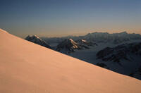
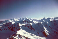
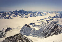
A low-light view of more of the St. Elias Range looking more or less northwest. |
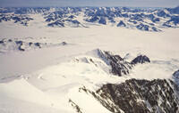
After rounding more onto the north side of the Mt. Vancouver, we could see Mt. Logan and the Bagley Icefield (Seward Glacier), along with the Hubbard Glacier to the right. |
Most of the climb to the summit was on the large northern snowfield. It was easy going, although, according to my logs, John Yates and I were slowed by the altitude. |
Bob Dangle with the Hubbard Glacier below. |
Duplicate. The lead team approaching the summit. The two teams got separated by enough that our times on the summit did not overlap. But all 8 of us made the top. |
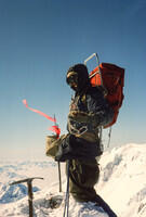
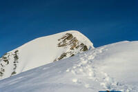
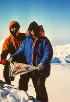
Cliff Cantor on the summit (north peak) of Mt. Vancouver. At an altitude of 15,825 ft, it is the 15th highest mountain in North America. Note that there is a range of elevations of 200 or more feet given in various references. |
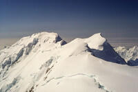
This photo was taken from the North Summit looking toward the Middle and South Summit of Mt. Vancouver. In principle, a careful analysis might be able to settle the question of which is higher, especially because the distant horizon is over ocean. Unfortunately there are haze and low clouds that make that problematic. |
Mt. Cook seen from the top of Mt. Vancouver. This is the next border peak going west from Mt. Vancouver. |
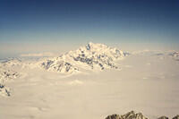
Mt. St. Elias seen from the top of Mt. Vancouver. At 18,008 ft, St. Elias is the 4th highest mountain in North America. The summit is only 12 miles from an arm of the Pacific Ocean in Icy Bay. |
Duplicate. Bart DeWolf (right) and Paul Ledoux on the summit of Mt. Vancouver with the MIT Outing Club Flag. |
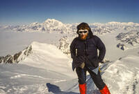
Bob Walker (Craig to most friends now) on the summit of Mt. Vancouver with Mt. Logan in the background. |
Looking down the Northeast Ridge of Mt Vancouver, our route, from the summit. |
The Hubbard Glacier with Mounts Hubbard (right) and Alverstone (left) beyond. Both of these are border peaks. |
Cliff Cantor hydrating. We took a stove to melt snow on the summit push. |
Duplicate. One of ice patches (slightly darker snow under the rope) that we crossed on the summit push. |
Heading back down past the cornices with Mounts Hubbard and Alverstone in the background. |
At our high camp in fine weather. |
We slept the night after the summit, then started down the following night. The weather had gone bad, with some fresh snow. This is Bart preparing to start down. Because of the weather, I don't have pictures of the descent. The snow was soft, and some of the cornices had fallen since our ascent. The gullies had clearly experienced much snow/ice/rock fall. |
A view toward the summit from lower on Mt. Vancouver. |
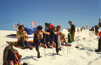
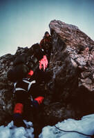
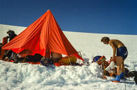
Back at Advance Base Camp, and fine weather. Our wands were handy drying racks. The people, left to right, are Bart, Cliff, Paul, Hal (almost hidden), Rob, and John. By elimination the hand and leg to the right are Bob assuming I took the picture. |
Our gully in the center of the picture. Much of the snow in it before the climb is gone. Note we cleared all of our gear, including the fixed ropes, off the mountain before leaving. |
Looking back up the mountain from Advance Base Camp. |
Back on the Hubbard Glacier after completing the first ascent of the Northeast Ridge of Mt. Vancouver. We had some more poor weather at the end. In fact, my log indicates the highest winds of the trip were at Base Camp after the climb. |
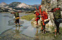
To finish off the trip, Bob Dangle and Rob Milne flew out to meet other committments. With them went most of our climbing gear, trash, and anything we would not need for a week long hike to the Alaska Highway, mostly over glaciers. |
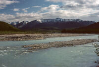
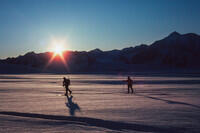
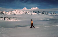
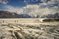
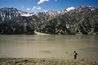
Starting the ski/hike out on July 5. Our Base Camp was about dead center, on the Hubbard Glacier, in this picture. The first task was to cross the glacier. Then we skied up the eastern arm of the Hubbard Glacier to the headwaters of the Kaskawulsh Glacier. We skied and hiked the full length of the Kaskawulsh to the Slims river, which we followed to the Alaska Highway at Kluane Lake. We took 7 days, of which two were cut short by illnesses. |
A view up a side glacier. |
I believe this is Mt King George from the east branch of the Hubbard Glacier to the mountain's east. |
A hiking camp looking back toward Mt. Vancouver. |
Antarctica? No, still on the eastern branch of the Hubbard Glacier looking back on, I think, Mt. Foresta, just to the right of Paul. |
Another camp on the glaciers near the region of transition from the Hubbard to the Kaskawulsh. |
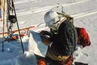
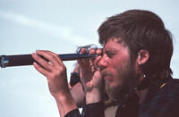
John Yates studying the map. There were glaciers going in many directions and we had to hit the right one. This was long before GPS. |
On the glaciers in the ice cap region. |
Another photo in the icecap region. |
Taking a break. |
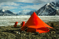
Another camp. The fly from my tent (the smaller North Face Mountain Tent) is being used separately as a sun shade. |
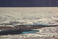
As we approached the region on the Kaskawulsh Glacier where there was net melting, we started to see surface streams like this. Eventually they would find a hole and plunge to the bottom of the glacier. Here we are still on snow, but soon we will be on ice where there is net melting each season. |
Duplicate. Now we're on the ice. We no longer need the skis, and, since there are no longer hidden snow bridges over crevasses, we don't need the ropes. Just don't step on something that looks like snow. Here I seem to be trying to bash Cliff with my skis. |
Heading down the Kaskawulsh. Much was like a superhighway. But there were occasional cravasse fields that took some effort to cross. |
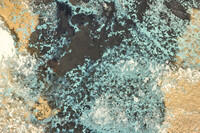
A close up of the dirty ice. As the ice melts, any dust and dirt that was in it accumulates on the surface until, near the mouth, it does not look like ice at all. |
Duplicate. Some ponds along the surface of the glacier. |
John Yates on a central moraine on the Kaskawulsh Glacier. The moraine is a part of the glacier that that marks the the join between the ice from two glaciers that merged upstream. Each of those feeder glaciers was subject to rockfall along its edge. The accumulated rocks are exposed as the surface melts and make the pronounced stripe down the middle of the main glacier. |
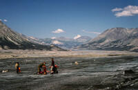
A camp on a central moraine. |
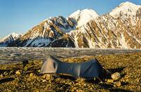
My tent at the same moraine camp. This was before the era of dome tents. |
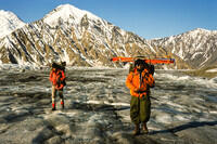
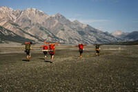
John Yates and Paul Ledoux walking down one of the "freeway" sections of the Kaskawulsh Glacier. |
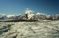
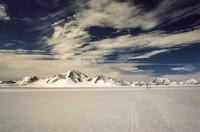
On the Kaskawulsh Glacier. Very often, when a photo of a classic valley glacier is shown in a publication, it is the Kaskawulsh. |
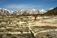
One of the crevasse fields. Usually the trick was to walk back and forth along the ridges between the cracks to find a place to jump. |
Hal Murray holding evidence of another long-ago traveler on the glacier. |
Approaching the snout of the glacier. At the end of the ice, the water appears from underneith the north side of the glacier and becomes the Slims River which flows to Kluane lake and eventually to the Yukon River. On the south side, it becomes the Kaskawulsh River which flows to the Alsek River and directly to the Pacific Ocean. Long after this trip, a geological event happened and the Kaskawulsh River captured the full flow from the Kaskawulsh Glacier. The Slims river basically dried up. |
We're still on the glacier, but it's covered with rocks. Soon we get off the ice and follow the south side of the Slims River. |
Cliff with our first plant in a month! |
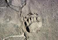
Duplicate. There are bears in this region. We didn't see any, but we were a party of six and they probably avoided us. |
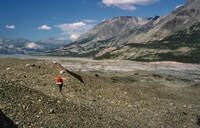
Hiking along the Slims River along an easy stretch. |
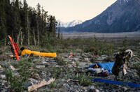
Our one campsite along the Slims River. We camped next to a stream which we used for water since we now had no snow or ice to melt. We had a bit of shock in the morning when the stream was gone - the snow upstream had stopped melting. But we could hear it uphill from camp so went to fetch water. |
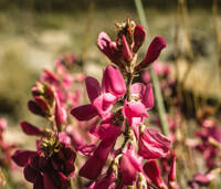
One of the flowers seen as we head for civilization and life. |
The Slims River, from before the recent capture of most of the water by the Kaskawulsh River. |
Thanks to spots like this, we ended up with wet and muddy boots. There was some quicksand, but we didn't have much trouble with it, although Cliff had an encounter. |
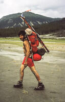
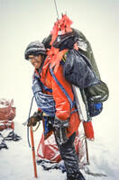
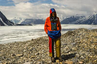
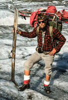
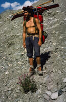
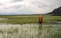
Cliff Cantor with his hike-out pack. |
More wet boots. There were places like this that we couldn't really avoid. |
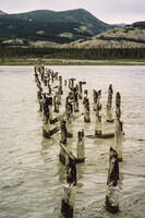
The remains of the old Alaska Highway bridge which we reached on July 11. Most of us waited at this location while Hal and Bart went for the van. We were pretty famished when we finally got to a restaurant in Haines Junction. Most had two full dinners. |