Navigation: Index page
Tatshenshini Raft Trip, 2012
During summer of 2012, I organized a private raft trip on the
Tatshenshini and Alsek rivers after five years on the waiting list
for a permit. There were 6 people on the trip - Ron
Thomas, Janet Brook, Pat Palmer, Kerry Luttrell, Sharon Luttrell and
me (Craig Walker). I had been on numerous previous trips with most
of them. Joan Wrobel also came along for the drive from New Mexico
to Whitehorse.
Joan, Pat, and I left Socorro on July 14 in my Suburban towing the
trailer full of rafting gear, including both Ron's and my catarafts.
Our first destination was Nanaimo BC where we spent a day with the
Luttrells. We then drove up Vancouver Island and took the ferry from
Port Hardy to Prince Rupert. From there we took the Cassiar and
Alaska highways to Whitehorse where Joan flew home and we picked up
the Luttrells. Finally we went to Haines where we met Ron and Janet on
July 23. We spent July 24 preparing all our gear at the Bear Creek
Cabins and making final shuttle arrangements with Stan Boor.
We launched on July 25 at Dalton Post and camped about a mile
downstream. The Tatshenshini was running about 3300 cfs which is more
like spring runoff than normal late summer. That had us worried about
the canyon which comes quickly after the putin and contains much of
the trip's whitewater. But it turns out the high water washed out
most of the obstacles, leaving mainly fairly big waves. With
catarafts that shed water instantly and having dealt with bigger waves
in the Grand Canyon, we didn't have much trouble. It might have been
a bit more "interesting" in non-selfbailing craft. At M&M falls, one
boat ran right over the hole without much trouble. It was probably
partially washed out.
After the canyon, the rough water abated but, at this water level,
was still interesting in several areas. Also, as we got farther down
the river, there were braided sections where navigation was not
simple. It wasn't always clear which channels would be the deep ones
so we had a few groundings.
We camped a night at Silver Creek, then moved to Sediments Creek
during our first of only two rain days. At Sediments, we took a
layover day and hike. From there, three more days of boating got us
to the the confluence of the Tatshenshini and Alsek, and a layover day on
Petroglyph Island. That is a very scenic place surrounded by
mountains and glaciers. In the distance up the Alsek, we could just
see a couple of the big St. Elias range peaks, probably Kennedy and
Hubbard. During the layover day, a short wade got us to a gravel bar
that we could walk almost to the Alsek.
We next camped at Walker Glacier were we took the obligatory short
hike to the foot of, and a bit onto, the glacier. One more
spectacular day got us to Alsek Lake and our final camp at the Knob.
The run from the outflow of the huge Novatak Glacier to Alsek Lake was
done in clearing weather with just enough clouds to add interest to
the views of the mountains. Mt. Fairweather (15300ft) was in view
ahead and the Novatak Glacier behind, with glaciers and mountains all
around the huge river. There was enough water to take the channel
behind the knob so we didn't need to face the icebergs of the "Channel
of Death". Note that the Alsek near the Walker Glacier was running at a
fairly normal 90,000 cfs when we were there. For scale, that is about
7 times the flow we had on the Colorado in the Grand Canyon in 2008.
We awoke the next morning at the Knob to totally clear skies! This
trip has a reputation for horizontal rain and many groups never see
the big peaks. We must be lucky. We spent the day at the lake and
took a short walk up the knob to get a good view of the river entering
the lake through the wall of icebergs. Later I took my raft out and
rowed among the smaller bergs - the ones too small to be a problem if
they rolled.
The weather finally gave us a taste of its normal self on the
final day with lots of rain and low clouds. We rowed to the takeout
at Dry Bay. Our ATV shuttle to the airport arrived before we had the
boats all the way apart and, despite the fog, the plane arrived before
we had the ATV's fully unloaded so we were on our way back to Haines
about as quickly as possible.
We spent one night in Haines, then the group separated. The
Luttrells, Pat, and I headed for Whitehorse while Ron and Janet
started their Ferry vacation to Sitka and Petersberg. The following
day, Pat and I headed for Skagway without the trailer and spent one
night there in the land of the monster cruise ship (4 in port). We
returned to Whitehorse, spent a night, said goodby to the Luttrells
and headed for home via the Alaska Highway and Whistler. We met Kerry
at Kelli's in Vancouver to return his gear. By the time we got home
on Aug 17, we were tired and very much ready to stop driving.
The photos follow. Most were taken with a Pentax K5 and one of
5 Pentax lenses - the 12-24mm and 55-300mm zooms, and the 21mm,
35mm macro, and 70mm limiteds. Some of the photos from the drive
were taken with my older Pentax K10D which I kept at the ready with
the long zoom for animals. I also had a waterproof Pentax W30 along
and mainly used it for movies in the canyon.
Navigation: Index page
Click on the image for a screen size version.
The "2000" and "full size" versions are larger (not available in web versions).
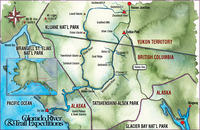
A map from the crateinc.com showing the location of the
Tatshenshini and Alsek.
|
The ferry to Nanaimo
|
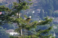
An eagle in front of the Luttrell's place.
|
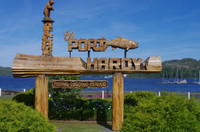
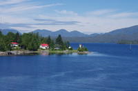
At a park on the shore, in front of our hotel, in
Port Hardy.
|
One of the lighthouses, near Bella Bella.
|
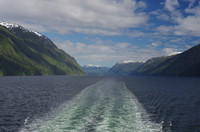
Along the fjords that the ferry is in most of the way.
|
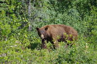
A black bear along the road. I saw nine bears from
the car, none on the river.
|
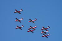
The Snowbirds giving Teslin a quick show.
|
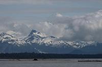
The Alaska Highway west of Whitehorse. You can
barely see a couple of high peaks of the St. Elias
range through the notch in the Kluane Mountains.
Those are some of the highest mountains on the continent,
but basically cannot be seen from any roads.
|
A hint of what is hiding behind the Kluane Mountains. This
was taken by me during a climb of Mt. Vancouver in 1975 looking
in the general direction of the Alsek.
|
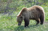
A grizzly along the Haines highway.
|
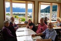
A meal at the harbor in Haines.
|
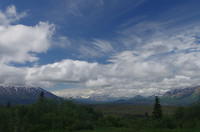
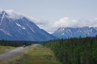
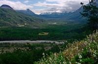
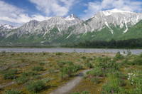
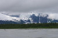
Looking into the Tatshenshini Valley from the Haines Highway.
|
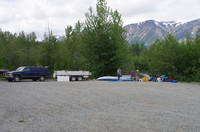
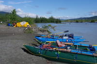
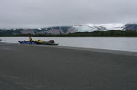
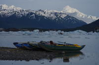
Rigging at Dalton Post
|
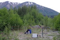
The first camp - the bear fence.
|
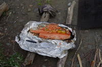
Salmon dinner
|
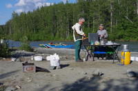
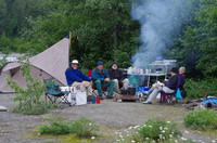
The kitchen.
|
The first camp. We don't have photos from the canyon. We did take some
movies, but don't have them prepared for the web.
|
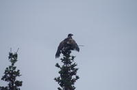
A bird (young eagle?) along the river.
|
The Sediments Creek camp.
|
The Sediments Creek camp from the hike into the hills.
|
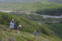
Descending from near the knoll we hiked to.
|
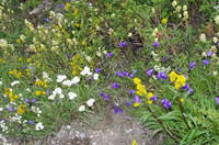
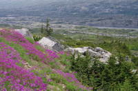
Many flowers in the high meadows.
|
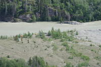
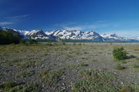
Looking over Sediments Creek and down the Tatshenshini Valley.
|
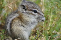
A chipmonk along the trail. Very tame - sniffed my
finger when I extended it.
|
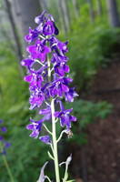
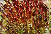
Larkspur
|
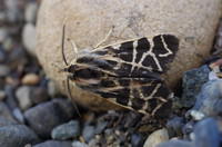
Moth near the camp.
|
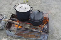
Our fire pan heating water
|
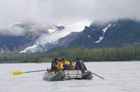
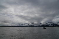
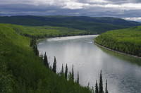
Heading downriver.
|
Another photo along the river.
|
Janet at the Petroglyph Island Camp
|
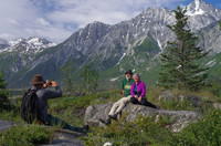
Ron at Petroglyph Island
|
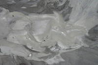
A "texture shot" of some mud on the Island.
|
Looking north across a side channel of the Tat.
|
The petroglyph. Not to impressive by Utah standards.
|
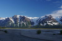
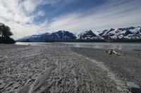
The confluence is a very scenic place!
|
Looking across the Tat to the south
|
Closeup of some peaks and glaciers across the Tat.
|
Another across the Tat.
|
Yet another across the Tat.
|
Looking back up the Tat.
|
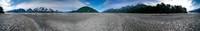
A 360 degree panorama starting looking up the Tat.
|
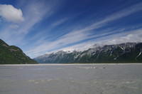
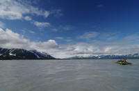
Looking up the Alsek. From near camp, a couple
of St Elias peaks could be seen - probably Kennedy
and Alverstone.
|
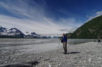
Looking down the Tat, with Craig.
|
The camp on Petroglyph Island.
|
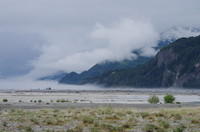
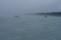
The morning we wanted to head down the Alsek, there
was fog. We did not want to row in it because of the
need to navigate the braids.
|
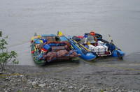
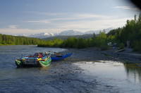
The boats loaded and waiting.
|
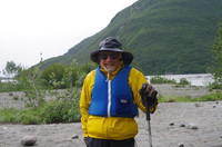
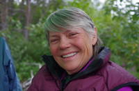
Pat
|
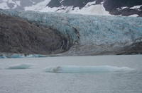
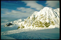
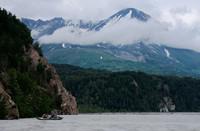
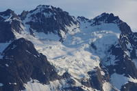
Walker Glacier and the lake below it.
|
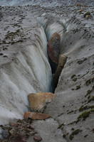
A crevasse on Walker Glacier.
|
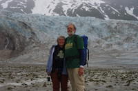
Ron and Janet at Walker Glacier.
|
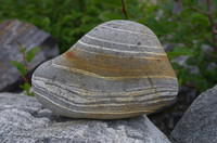
A rock near Walker Glacier.
|
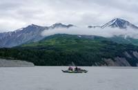
The boats and Walker Glacier from Dipper Creek.
|
Walker Glacier with a slight break in the clouds.
|
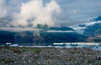
More glaciers downstream from the Walker Glacier
|
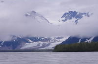
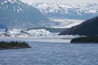
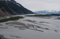
The Novatak Glacier filling the wide valley north of the Alsek.
|
Yet more glaciers as we approach the Novatak drainage.
|
Looking downstream from near the Novatak.
|
A flower at our lunch stop at the Novatak drainage. Anyone know
what it is?
|
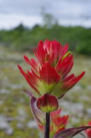
An indian paintbrush at the lunch stop.
|
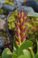
A strange flower at the lunch stop. Anyone know what it is?
|
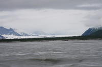
Mt. Fairweather (15,325 ft) looming through the clouds during the final
stretch of river from the Novatak Glacier to Alsek Lake. We're
nearly at sea level.
|
Looking back toward the Novatak Glacier as we head for Alsek Lake.
|
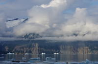
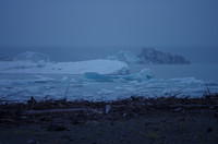
From the scout of the "Channel of Death" - looking for an opening
through the icebergs that block the Alsek River where it enters
Alsek Lake. The glacier beyond is the Grand Plateau Glacier.
|
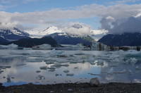
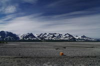
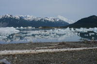
Looking across Alsek Lake from the campsite on the Knob to Alsek
Glacier and the Fairweather Range.
|
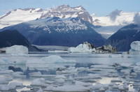
Another looking across to the Alsek Glacier and Fairweather Range. There
are numerous large icebergs in the lake.
|
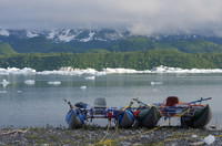
Our boats parked at the Knob.
|
Mt Fairweather and icdbergs.
|
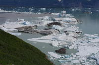
The Alsek Glacier entering Alsek Lake.
|
Looking north across Alsek Lake from the Knob.
|
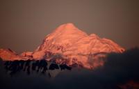
Mt. Fairweather late in the day.
|
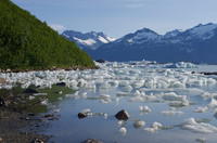
Looking from camp along the side of the knob over the field of
small ice blocks stuck there.
|
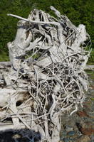
A dried root ball at camp on the knob.
|
From high on the Knob, the view of the river leading toward the
"Channel of Death".
|
The icebergs of the "Channel of Death". The wind blows them until
the current of the river prevents going farther, where the accumulate
into a wall that can be impassable.
|
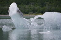
A small iceberg on Alsek Lake.
|
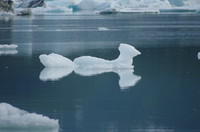
Another small iceberg.
|
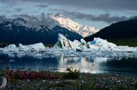
Clear skies, Alsek Lake, icebergs, and Mt. Fairweather.
|
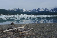
More of Alsek Lake and icebergs.
|
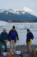
Finishing the cleanup process with Fairweather in the background.
|
The rafts and Mt. Fairweather.
|
The last day - rain and fog. Reputation has it that this is
typical weather for this trip. We only had 2 rainy days out of 12.
|
Heading down the last few miles of the Alsek in the company of
icebergs that had managed to get over the shallow water leaving the lake.
|
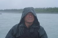
Kerry in the rain.
|
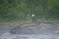
A bald eagle along the river.
|
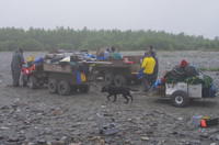
The ATV shuttle from the takeout to the airport. The channels that used
to allow rowing to the airport in higher water are now dry.
|
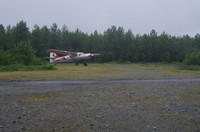
The chartered Otter from Yakutat Coastal Airlines arriving to take us to
Haines despite the low clouds.
|
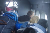
Crammed inside the airplane. One of my raft tubes kept trying to roll
onto Ron.
|
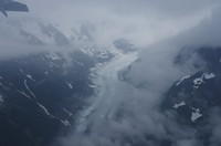
One of the glaciers as we neared Haines. The flight would have been
spectacular I'm sure if it had been clear.
|
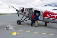
Unloading in Haines. After the plane was empty, he rolled over to
the taxiway, gunned the engine and almost literally jumped into the air.
|
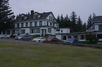
The Halsingland Hotel where we spent the night and cleaned up. All the
gear is rather wet at this point. We were able to dry it in Whitehorse.
|
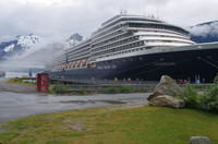
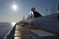
The cruise ship Zuiderdam in Skagway.
There were three other ships of similar size in town.
|
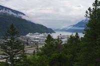
Four cruise ships can be seen here with Skagway to the left.
|
Back on the highway to Whitehorse.
|
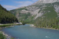
The Laird river from the Alaska Highway.
|

The Laird Hot springs.
|
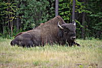
A relaxing wood buffalo along the Alaska Highway.
|
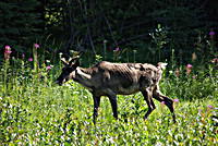
A caribou along the road.
|
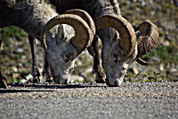
A couple of stone sheep on the road.
|
The Alaska Highway and, I think, the Toad River.
|