Thelon River 2004
Edited by Craig Walker
The Thelon River is located about 300 miles northeast of
Yellowknife in Canada's Northwest Territories and Nunavut. It runs
through the Thelon Game Sanctuary, a haven for large herds of caribou
an significant numbers of muskox. Along the river, there are pockets
of trees in a region that is otherwise well north of the continental
tree line. A group of six of us ran the 160 mile section of the river
between the confluence with the Hanbury River and the Thelon Bluffs
over a 2 week period in mid August of 2004. The group was Walter
Brisken, Emma Goldberg, Ron Thomas, and I from Socorro, NM, and Jan
and Rich Roenisch from near High River, Alberta. Jan is my sister.
Our charter flights originated in Yellowknife. The flights to the
Thelon are very long so, to save on charter costs, we rented canoes
that were prepositioned at the river. Those canoes obviously lead a
hard life, but this section of river is not difficult so that was not
much of an issue. Our logistical arrangements were made through Great
Canadian Ecoventures in Yellowknife. One has to be flexible on these
northern trips. One of the two flights that it took to get all of us
to the river was the day after planned and the pickup flight was also
delayed by a day.
We planned to canoe on approximately 8 days and hike or rest on the
others. Some of the best potential hiking is in the area were we
started the trip so we spent an extra day there visiting Warden's
Cabin and the hills behind. The cabin, or rather cabins, are left
over from a short period when there actually was a resident warden in
the Thelon Game Sanctuary. We had a rest day half way through the
trip - preplanned, but also enforced by high winds. At the end of the
trip, we got to the takeout location a day early as insurance against
having an uncanoeable day at the end. We intended to hike in the
location, but ended up not going far partly because there was a
grizzley wandering the area.
The most unique hike happened early in the trip. Before leaving,
we (ie Walter) had the crazy idea to visit a "confluence".
There is a project based on the Internet where the object is to visit
those places where even lines of longitude meet even lines of
latitude. This is sort of a GPS geek thing, but it does give one the
excuse to visit various random spots. The Thelon comes within about 3
miles of the intersection of 104 west longitude and 64 north latitude.
A quick check at the web site showed that no one had reported visiting
this confluence, or any other within several hundred miles. We could
be the first. We arrived at the place where the river comes closest
to the confluence about midday on Aug 12 in decent weather. There was
a good campsite there so we decided to go for it. Our maps
(1:250,000) showed a lake wrapping part way around the point. We knew
we could get close, but we weren't sure we could get across the lake
without going a long way around, or taking a canoe. Fortunately it
was really two lakes with a shallow stream between and we were able to
cross and get to the point where our GPS units (Walter, Ron, and I all
had receivers) indicated the magic location to be. A picture from the
confluence is below.
In hindsight, it is clear that doing this trip earlier would be
much preferred. We saw some animals including 2 bear, a wolf, 3 moose, a
wolverine (a first for most of us), an ermine, a few caribou and
various birds including bald eagles, swans, cranes, geese and terns. We
saw no muskox. Compared to what parties normally see earlier in the season,
this is not much. In addition, after moderately warm weather for the
first few days, the rest of the trip was cold, windy, and wet. If I were
to do the trip again, I would try to do it in mid July. Unfortunately
this year, other commitments made that impossible. The one flip side
of going earlier is that the bugs can be intense in warmer weather, as
we experienced early in the trip.
The names in parenthesis indicate the photographer.
RETURN TO PREVIOUS INDEX
Click on the image for a screen size version.
Any links to "full size" versions will be broken when viewed on the web
(they're too big).
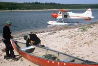
| We flew to the Thelon on a Beaver in two trips. This is at the
river on the second trip. The canoes needed some repairs, for which
the pilot had brought some tools.
(Craig)
|
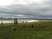
| There were blueberries everywhere, it seemed. They considerably
slowed any hiking. You just couldn't walk past, or on, too many before
succumbing to the temptation to have a snack. Here Jan, Craig, and Ron
are grazing blueberries near Warden's Cabin, looking over the Thelon.
(Rich) |
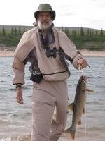
| We had fish on at least half the nights, which was about all we
wanted. This is Ron with a lake trout. Mostly we caught Northern Pike.
(Craig) |
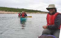
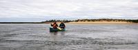
| Here we are leaving the first camp. I am in the stern of Ron's
boat with Walter and Emma in the green boat and Rich and Jan in the
red boat beyond.
(Ron) |
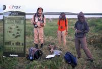
| Ron, Walter, and Emma at the 104W/64N confluence (see the text
above). It is just an undistinguished spot on the tundra near a lake,
but it gave a good excuse to go see some country away from the
river. (Main: Craig - Inset: Emma) |
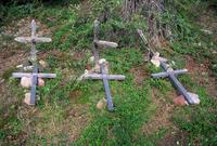
| Hornby cabin, where John Hornby, Edgar Christian and another (I'll
try to find the name) died while trying to winter over, living off the
land in 1926-1927. The caribou didn't come and they starved. Edgar
kept a diary so the tragic tale is known in detail. These are their
graves with the original crosses, which are badly decayed, and some
more recent replacements. (Craig) |
| Ron and I stopped at one random spot on the 40 mile day to
photograph the other boats going by on the river. Here you get some
idea of the size of the river. A moment later, I got a surprise when I
looked around the corner and saw rapids which definitely were not
expected. And the lead boat had no whitewater experience! We
scrambled to catch up, but fortunately the others had avoided the few
bad spots and there was no trouble. (Craig) |
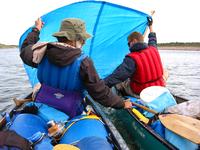
| On the long day with tailwinds, we tried sailing for a while
using tarps. At first there were two canoes and a small tarp as shown
in this photo. Later
we had all 3 canoes and a larger tarp. It probably wasn't faster
than paddling, but it was more fun and easier. (Craig)
|
| Canoeing in decent weather. Many of the river banks were sand.
(Craig) |
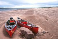
| Wind and blowing sand during the day we stayed in camp about half
way through the trip. This picture captures something of the bleak
feeling of that day. The canoes were tied to a boulder and contained
several large rocks so they were not in danger of blowing away. Note
the new sand dunes forming around the canoes. The third, smaller
canoe was in the willows back at camp. (Craig) |
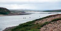
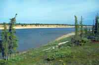
| This is near our pickup spot. A group of 8 from a YMCA group
arrived the morning after us and ended up sharing the same flight out
with us. This was the largest of 4 other parties that we met during
the trip. The photo is taken from the location of an unmanned water
gauge and small government cabin (locked). You can get real-time
water depth and air temperature data from that gauge on the Internet.
Follow this link.
From this area a grizzly was visible grazing on berries something over
a half mile away. He did not show signs of being aware of our presence.
The actual pickup spot was a short distance downstream, on the other
side of the river. (Craig) |
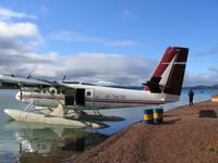
| The Air Tindi Twin Otter that carried us and the YMCA group
from the river to Yellowknife. This is at the fuel stop at Reliance
at the east end of Great Slave Lake. The plane is large enough to carry
all 14 of us and about half the gear. The Beaver came later to pick
up the rest of the gear. (Ron) |
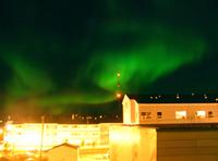
| We had a treat during our one dark night in Yellowknife - northern
lights. We watched and photographed them for quite a while. The
digital camera, with its immediate feedback, was very useful for
this. Exposures had to be many seconds, even at high ASA settings.
(Craig) |